Zavoiela Tract – Zakukul Medow
-
Difficulty
Середня -
Length
4,2 -
Duration
2,5
-

The Zakukul meadow is located at an altitude of 1436 m a.s.l. This is a real center of traditional farming. Here shepherds still graze cattle, make cheese, and preserve ancient traditions of local inhabitants called Hutsuls.
The trail starts at the checkpoint in the Zavoyela tract. It passes along a gravel road to the crossroads for 800 m. Then it turns right and leads along the stream to the forest. Having crossed the stream, you will find yourselves in a spruce and beech mixed forest. Then you have to climb a steep slope which requires some physical effort. It’s just 400 meters up. Then the trail becomes gentler and winds its way through a spruce-fir forest. The dense and calm forest space with shady alleys will provide you with some comfort even in hot weather.
-
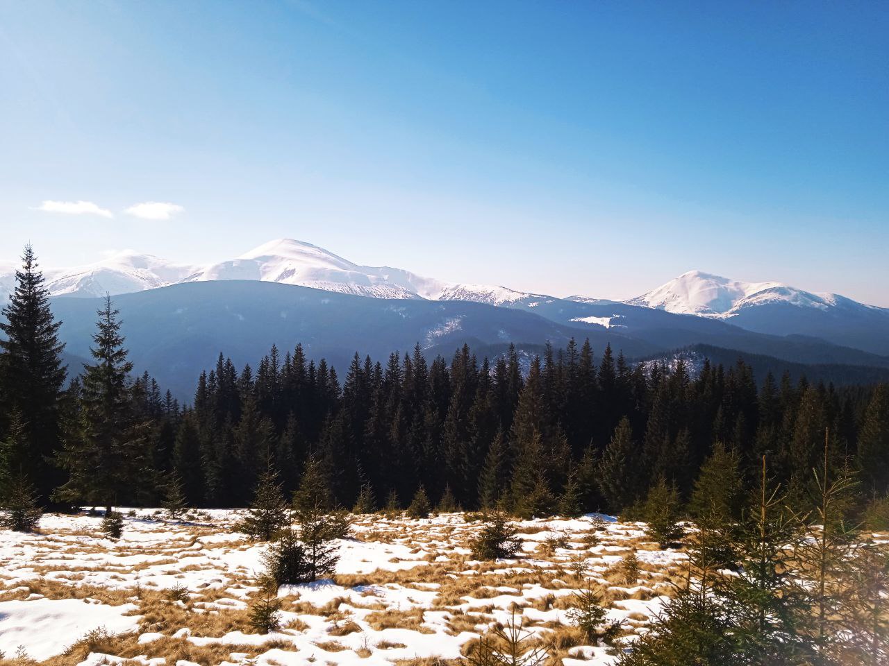
A significant part of the trail runs through beech and fir-beech forests, which extends to an altitude of 1000–1100 m a.s.l.. Here the diversity of flora species depends significantly on features of its relief, composition of rocks, orientation of slopes, and amount of moisture. In particular, the European beech (Fagus sylvatica) dominates in rich calcium areas. The European spruce (Picea abies) occupies high-altitude mountain belts mainly, with cool and humid conditions. This species grows well on steep slopes and in moist intermountain hollows. A zone of beech-fir-spruce, fir-spruce forests, and spruce forests stretches from 1100 m to 1450 m a.s.l.. This area is featured by alternation of pure spruce stands with mixed forests. Such forests protect against winds, mudflows, avalanches, and soil erosion.
Along the trail, forest areas often change to meadows that arose as a result of human activity. Plants such as blueberries (Vaccinium myrtillus), matgrass (Nardus stricta), red fescue (Festuca rubra), and common bent (Agrostis tenuis) predominate here. Rare plants also grow at the meadow.
-

In a distance of about 2.5 kilometers, the forest thins out and the Zakukul meadow opens to visitors.
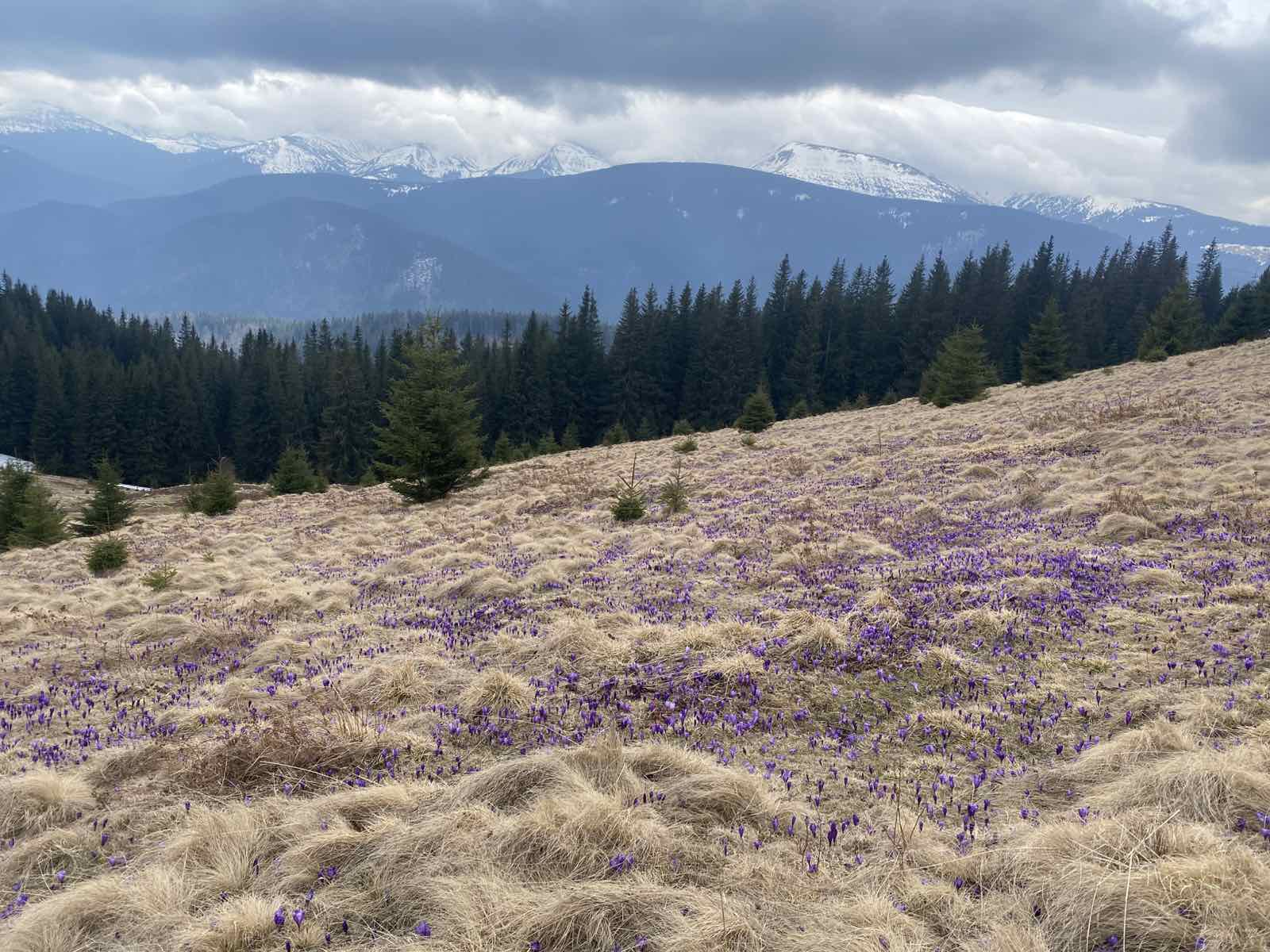
Impressive panoramic views of Hoverla (2061 m a.s.l.) and Petros (2020 m a.s.l.) open from its top. Mount Kukul rises above the meadow and the mountain range of the same name stretches. The Polish-Czechoslovak border was marked here during the interwar period. Currently, this is the border between Ivano-Frankivsk and Zakarpattia oblasts. During World War I, fortifications and defense lines were constructed here. Today remnants of trenches, dugouts, and concrete structures remind of fierce battles which took place in this area.
In the spring the meadow turns into a purple-lilac field due to the mass blooming of the Crocus heuffelianus, a rare plant that is under threat of extinction. Picking these flowers or damaging them harms nature and also involves administrative liability.
Deviation from the route.
Damage to natural objects.
Breeding hearths in places not designated for this purpose, smoking when passing through forests.
Felling and damage to trees plucking flowers, collecting medicinal plants.
Hunting for animals, destruction of their habitats.
Catching fish by any means.
Stay with firearms.
Territory littering, noise.
Report to The State Emergency Service before you go on a hike, so that rescuers can find you quickly and in time if something happens. This requires only two steps:
-
Fill out the online form
Fill in the online form to inform the mountain search and rescue units about the planned trips to the mountains.
Online form -
Save the contacts of rescue units
Make a note in your mobile phones of the mountain search and rescue units of the area in which you are going to travel.
Contacts of divisions